My stubbornness paid off
Another day of sightseeing from my base in Cherokee. The day before, I had visited the six counties located in the absolute southwestern part of North Carolina, and today I wanted to see see more of the area, not least more nature. In the endI succeeded though, even if it didn't go exactly as planned. My first goal was Clingmans Dome, the highest mountain in the Great Smoky Mountains range. I had been told that from the peak there should be great views of the surroundings. So when I had had some breakfast and a cup of coffee I left the hotel. Unlike the day before, I left a little after 8 am and that was on purpose. I knew there would be many tourists in the Great Smoky Mountains National Park, and therefore I would like to get there before all the others also arrived. Also because the view is usually the best in the morning before the heat is creating a mist. Before I left town, I filled up the car, as there are no gas stations around if you run out of fuel inside the park.
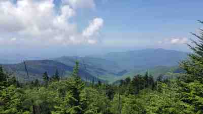 View
of Great Smoky Mountains from the parking lot at Clingmans Dome.
View
of Great Smoky Mountains from the parking lot at Clingmans Dome.
Just outside Cherokee on US Highway 441, which leads through the park to Tennessee, you find one of the park's visitor centers that I had planned to visit on my way back. Just before I reached the visitor center, the car in front of me came to a stop, and when I got up behind him, I could see that it was because there was a herd of elks grazing in the median strip. I took a few pictures before I slowly drove by. From Cherokee there are approximately 25 miles (40 km) to Clingmans Dome, but I didn't get that far because after around 15 miles, the car computer announced that the tire pressure in my left rear tire was far too low, only 26 psi (equivalent to 1.8 kg per cm2), but it did not tell me what it should have been. Had there just been a single pound missing, I would probably have continued, but now I did not dare take the chance, so I returned to Cherokee. The first stop was at the gas station, where I had filled up the car before I left town, but they did not provide an air pump so I proceeded to another gas station further down the road. Here they had air and also a very friendly lady who would like to show me how their system worked. It cost $ 1 to get air here which I paid with four quarters (25 ¢) in the vending machine, and she measured the tire pressure. Unfortunately, their pressure gauge indicated that the pressure in the tire was 50 psi, and that did not sound right. The friendly lady didn't think so either and stated that the tire gauge was probably out of order. Someone had actually told her so earlier on. She therefore recommended that I should visit a tire center on my way out of town and gave me thorough instructions on how to find it. And I did without getting lost. Inside the "shop" I spoke with a man who turned out to be the owner of the place and he asked me to drive up in front of the workshop and then he would send someone out to look at it. I did that and a young man came out with a hose, a pressure gauge and a spray. He measured the tire pressure and, unlike me, knew the right pressure to be 35 psi (2.5 kg / cm 2). He corrected the pressure and then he used the spray (or rather the content of the spray) to check if the tire had a puncture, but fortunately it hadn't. He then offered to measure the other tires as well, and it turned out that none of them had the right pressure! One was missing air while the other two had too much, so he regulated those as well. He then announced that he was sure that the pressure had been incorrect already when I picked up the car. The Avis lady who received the car on my return was told so, in a way indicating that I was not happy about it but of course in a polite way, as she wasn't responsible for the trouble I had. The young man who was Cherokee which is not rare around Cherokee couldn't help me reset the car's computer, which still was showing too low tire pressure in the wheel because he did not know the model I drove and since there is never an instruction book in rental cars, we could not find out how. I wasn't charged anything for the service, but I gave the young man $ 10 for his help, and then I left and I didn't get any problems with tire pressure later. The next day, I also happened to reset the computer myself by pressing various options in the computer menu. What else I did, I have no idea, but apparently it did not affect the car's driving capabilities.
As I was now back in town, I decided to postpone the visit to the national park, which later turned out to be a bad decision. Instead, I drove west to Bryson City, county seat of Swain County, which I had planned to visit later on. Bryson City is 10 miles (16 km) west of Cherokee and it took only about 25 minutes to get there. In Bryson City I saw the old courthouse, now a museum, which the locals think has a very interesting clock tower. The day before, I had seen some other courthouses in other counties, many with clock towers, and I don't actually think the clock tower in Bryson City was anything special - but after all I'm not that local. I also took a walk in downtown, something I've never done before, and I saw Everett Hotel, which is housed in a building that was originally a bank, but was converted to a hotel in the sixties. It looked interesting and when I read about it online, I agreed with myself that I would like to stay there the next time I get to these parts, but we'll see when that will be. Right next to the hotel and courthouse/museum was a Historic Marker who said that Tsali, a cherokee, who had fled from American troops at the time of expulsion in 1838, had been executed close by. That story I have told on my Historic Stories page. As there was nothing more in Bryson City that I wanted to see, I returned to Cherokee. I had actually considered a trip with a tourist train from Bryson City to Natahala Gorge, but unfortunately the train had left for its 4.5-hour trip when I reached the station. Back in Cherokee I took a short break at the hotel - for biological reasons - and then I returned to the national park.
This time I reached the parking lot near the top of Clingmans Dome without further ado. From here, a half a mile (800 m) paved trail leads up to a viewing tower at the peak of the mountain. The trail ascends 300 feet (100 m) and it will take at least 30 minutes to walk to the top if you are in good shape or more, up to maybe an hour, if you are not. It was not a problem for me, because when I got there, there was absolutely no free space in the parking lot. Just before I entered the lot, there were signs telling "No parking at roadside". There were several who parked there anyway, so I considered it too, but when I drove by for the second time, two park rangers were busy issuing parking tickets, by placing them under the windshield wipers of the illegally parked cars. I would not take that risk, so after driving around the parking lot a couple of times or four, without anyone having bothered to move their car and let me get a spot, I gave up on that plan. Instead, I stopped for a moment somewhere without cars at the road side, so I could take a few pictures out of the window of the famous view, which was also beautiful, although hazy.
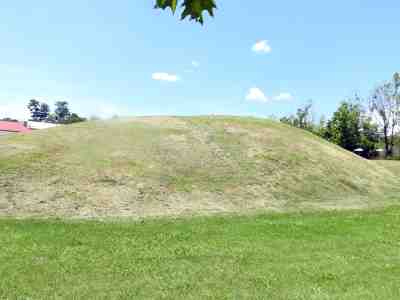
The small mound in Franklin, once the location of the counsil house of Cherokee village, Nikwasi.
As I had not spent that much time in the national park, it was far too early to return to the hotel so I decided to go back to Franklin and look for the mound that I had not found the previous day. After a short stay at the visitor center - now the elks were gone - I left the park and about two hours later I was back in Franklin. I had gotten the brilliant idea that as I hadn't been able to locate the mound before, it might be located on the opposite side of town, so I there I went. It just did not work out the way I wanted! I still couldn't find that d… mound. Franklin is located on the banks of the Little Tennessee River, so I thought that at least I could go for a walk along the river. After purchasing a sandwich and a cup of coffee on the same gas station as the day before, I would therefore head for a parking lot by the river. That is, I never got that far because when I left the store with coffee and sandwiches in my hands, I saw the mound just across the street. How I had avoided seeing that the day before, is still is beyond my imagination. I ate the coffee and drank the sandwich in the car - or vice versa, and then I went over to see the mound which, as expected, was a small grassy knoll with a historic marker telling about Nikwasi, the Cherokee village that used to be on this spot. As it was still not that late in the afternoon, I continued south towards Highlands, which besides Franklin, is the only actual town in Macon County. The goal was not actually the town itself, but some waterfalls nearby.
The road between Franklin and Highlands runs through the Nantahala National Forest and is quite pretty, but not exactly a freeway. I got to see two of the three waterfalls that I passed. At the third, the small parking lot was completely filled up, so I gave up on that. The first place I stopped was at Cullasaja Falls, a waterfall on the Cullasaja River. Here I have taken pictures of both the river and the waterfalls - or at least one of the waterfalls that make up the complete fall, which is 250 feet (77 m) over a stretch of 900 feet (300 m). Cullasaja comes from the Cherokee language and means in English "Honey Locust Place". I was at the bottom of the falls that end in a pond. Here there were some children who bathed and someone who used the waterfall as a water slide, so I assume that the rocks below the water must have been worn fairly smooth. My next stop was at Bridal Veil Falls, which is a fall on a tributary to the Cullasaja River. "Creek" is probably closer to the correct term than river, and here on a summers day after a period with no rain, there was not much action from this waterfall. The water drops 40 feet (12 m) from a cliff above a path, so you can actually walk behind it, and of course I did. You can also drive under it and it is the only waterfall in North Carolina where this is possible. However, it was not possible for me as the road was blocked by a bar when I was there.
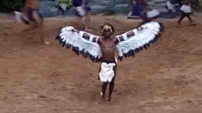
"The eagles dance" from the performance of "Unto these Hills". The eagles dance was danced after the victory over the Creeks in The Battle of Horseshoe Bend in 1812.
After visiting the two waterfalls I headed back to Cherokee where I arrived around 6 pm. I decided to postpone my dinner until after the show I was going to was over, so instead I had a cup of coffee in the hotel lobby. At 6.30 I drove up to Mountainside Theater. Here the parking assistants guided me to a parking lot, which I didn't knew existed, even though I have been on site several times. I parked the car and went down and took my place in a fairly long line of people, waiting to be let in. At 7 pm the gates opened, and then it didn't take long to get in. When I discovered a booth selling salted popcorn and not just the buttered versions that Americans love so much but which I hate (my son would probably claim that is not popcorn at all but candy), I bought a box of these, and then I found my place that turned out to be right in the center of the stands. At 7.30 the entertainment began with some children singing and dancing and at 8 the show began. "Unto these hills" tells the story of the Cherokee people from their first meeting with Europeans in the shape of the Spaniard Hernando de Soto and his expedition in 1541, and forward to the forced removal 1838. The main emphasis is on the period just before the Trail of Tears, the name that the forced removal is known by, because between 4 and 8,000 of the 17,000 Cherokees who were removed died on their way to Oklahoma. In the show you meet famous Cherokees such as Tsali, mentioned above, Yonaguska, chief of the Quallatown group, Junaluska, leader of the Snowbird Mountains group, and William Holland Thomas, the only white who has ever been the principal chief of any branch of the tribe. But also famous white people like Samuel Houston, Andrew Jackson and several others appeared in the performance. It turned out to be a fantastic experience, which I will of course see again if I get back to Cherokee.
After the show I returned to town, but as it was past 11 pm before I got back, I gave up on dinner and went to bed instead. The next day I had to drive to Wilkesboro, a journey of 160 miles (257 km), which could be done in about 3 hours, but of course I wanted to see something along the way so I was certain it would take me a while longer.
-
Return to Summer in Western North Carolina -
- Return to Travel page -