Bridge, bullets, bats and a cavern.
The next days trip was pure
transportation.
We were just going north, to our next overnight stay in Raleigh, North Carolina. We took Interstate 95, from Santee to Benson, NC and then I-40 to Raleigh.
In Raleigh, we quickly
found our hotel and got our room. Our rooms was in opposite ends of the hotel,
and Dorte and I got a room in the "wrong" end. This part of the hotel looked
more like an abandoned military hospital than a hotel. Dull,
green-painted walls with dull gray carpeting, and no windows in the hall, but
the room was OK. The kids had a room which exited to a outside gallery and all
the rest of our company were in the same part of the hotel. After checking in, we went out on an expedition to an outlet in
order to get a swimsuit for Dorte, and this time we suceeded, so we hurried back
to the hotel to inaugurate it. The only problem was that a lot of young
boys and girls were staying in the hotel and they all seemed to be in the pool when we
returned. Anyway we managed to take a swim before dinner that night.
 After dinner everyone wanted to relax at their
rooms except Dorte and I, who would rather go down town to enjoy some night life.
We drove toward the city center, but without seeing anything. Indeed, we didn't
see a single living soul in the streets except for people in cars, and suddenly
we were out of town again, so we continued a little further and then turned
around. We took another route back through the town center, but with the same
kind of luck. Although it was Saturday night nothing seemed to be open. We
therefore chose to return to the hotel but bought a couple of beers at a gas
station, which we drank before we went to bed.
After dinner everyone wanted to relax at their
rooms except Dorte and I, who would rather go down town to enjoy some night life.
We drove toward the city center, but without seeing anything. Indeed, we didn't
see a single living soul in the streets except for people in cars, and suddenly
we were out of town again, so we continued a little further and then turned
around. We took another route back through the town center, but with the same
kind of luck. Although it was Saturday night nothing seemed to be open. We
therefore chose to return to the hotel but bought a couple of beers at a gas
station, which we drank before we went to bed.
Next morning the whole party met in the hotel's "breakfast
room" to enjoy the included breakfast. It turned out that breakfast consisted of
coffee, juice, sandwich bread with jam, muffins, fruit and juice. Or rather this
was what should have been on the buffet. Unfortuately somebody got to it before
we did, because there was no juice, coffee or toast. All that was left were four
muffins, and some not to good looking apples. We chose to have our breakfast along the
way and found a Denny's close to the hotel.
After breakfast we took U.S. Route 40 a few miles north to Durham, then changed to
U.S. 501 to Danville, Virginia. From there we took even smaller roads to
Lynchburg, also in Virginia. It was Sunday and it was time for church, and it
showed. The roads were almost empty, but the parking lots outside the churches
where filled to the brim. The few cars we met were clearly locals, and I assume
that they believed everybody knew their habits as noboody gave any kind of sign before
turning either left or right, and cars came rushing out of side roads without
stopping etc., so I assume that they trusted that everyone in the area knew that
they were driving this particular route every Sunday at that time. "The winner" was a car that
rushed out from a driveway in front of us on the right hand. I had to jump on
the brakes to avoid a collission. After that he drove calmly, extremely calmly
on the narrow roads, where it was impossible to pass him. His speed was rarely more
than 20 miles per hour, and despite the fact that we repeatedly changed direction,
he never once useed his turn signal on the 8 miles that we were behind him.
Beside from that everything went well, and we saw an area of the state that we
would not have seen if we had stuck to the freeway.
When we got to Lynchburg I would have traveled west to
the Blue Ridge Mountains near the town of Montvale in Bedford County to take on
treasure hunting.
"I have deposited in the
county of Bedford, about four miles from Buford's, in an excavation or vault,
six feet below the surface of the ground, the following articles, belonging
jointly to the parties whose names are given in number "3," herewith:
The first deposit consisted of one thousand and fourteen pounds of gold, and three thousand eight hundred and twelve pounds of silver, deposited November, 1819. The second was made December, 1821, and consisted of nineteen hundred and seven pounds of gold, and twelve hundred and eighty-eight pounds of silver; also jewels, obtained in St. Louis in exchange for silver to save transportation, and valued at $13,000
The above is securely packed in iron pots, with iron covers. The vault is
roughly lined with stone, and the vessels rest on solid stone, and are covered
with others. Paper number "1" describes the exact locality of the vault so that
no difficulty will be had in finding it.
This text comes from the famous or infamous Beale papers,
written in code, and the above text is the only part that has been dechipered. The
remaining to pieces of paper with coded numbers are still not resolved. Paper 1
is the most interesting, because it would tell exactly where the treasure is buried.
The "Buford's" of the letter is the village, which today is called Montvale,
approx. 40 miles west of Lynchburg. Countless people have been looking for the
treasure without luck. As many claim that this is a hoax, and that there has
never been a burried trasure, and a few is asserting that
they themselves have found the treasure while others thinks that it has been
found and removed many years ago. Anyway I didn't get the chance to go
looking, because the rest of the family would rather see the rock
formation Natural Bridge in Rockbridge County somewhat further north in the Blue
Ridge.
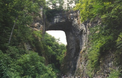 Natural Bridge is located on the edge of the Blue Ridge
Mountains, not far from the Blue Ridge Parkway. "The Bridge" is a natural rock
bridge, created by the Cedar Creek, which over millennia has eroded the soft
rock of the mountain away leaving only the hard parts. The bridge is considered
to be one of the world's natural wonders. From the ticket office it was possible
to walk down to the bridge (there was a stairway with 137 steps) or you could
take a bus. Else, Carl and the four young people that were with us that day
(Tim, Tina, Jill and Lasse)
took the bus, while Dorte and I walked down.
Natural Bridge is located on the edge of the Blue Ridge
Mountains, not far from the Blue Ridge Parkway. "The Bridge" is a natural rock
bridge, created by the Cedar Creek, which over millennia has eroded the soft
rock of the mountain away leaving only the hard parts. The bridge is considered
to be one of the world's natural wonders. From the ticket office it was possible
to walk down to the bridge (there was a stairway with 137 steps) or you could
take a bus. Else, Carl and the four young people that were with us that day
(Tim, Tina, Jill and Lasse)
took the bus, while Dorte and I walked down.
When we came to the foot of the stairs, we studied a
sign stating that the bridge had developed through 200,000 millions of years of
erosion! 200 million is probably more likely, but maybe this bridge is older than
the rest of the universe! The actual bridge spans about 90 feet and and is
between 50 and 100 feet wide. The bridge is crossed by present day U. S. Route
11.
In the 1740s the area belonged to the English crown (the
Native Americans that lived in the area had not been asked), and the Governor of
Virginia arranged an expedition in 1749, that aimed to find a way across the Blue Ridge. Leader of the expedition was Colonel Peter Jefferson and one of the
participants was a young George Washington. 23 feet up on the cliff's side under the
bridge, the initials GW have been found scratched into the rock, and some
believe that it is Washington's initials, thus making him USA's first known
graffiti artist. In 1774 one of Colonel Jefferson's relatives, Thomas Jefferson,
who later was to become the third president of the United States, bought the
area of the English king for 20 shillings. Had King George known that just
three years later Jefferson would be one of the ringleaders behind the USA's
secession from England, it is uncertain wether he would have sold for that
price :-)
Before the whites came to the aera it was inbhabited by
Monocans and they have their own story about the bridge.
"Once the peaceful Monocan Indians, were chased by the
warlike Shawnee and Powhatan Indians. During the flight the Monocans discovered
a wide canyon in front of them. They fell on their knees and with bowed heads,
they called out to The Great Spirit for help. When again they raised their
heads the Great Spirit had created the the gigantic stone bridge. The
Monocans fled across the bridge and escaped their enemies. Since they hold the bridge sacred.
"
On summer evenings "The
Drama of Creation", a sound and light show is enacted at the bridge. We were so
lucky only to visit at daytime so we
were spared the show. During the American Revolution, the revolutionaries made a different
and more practical use of the bridge. The soldiers threw lumps of molten lead
down from the bridge. Gravity caused these lumps to become spherical, and when
they hit the cold water in the river under the bridge they stiffened in this
form, after which they could be retrieved and used as rifle bullets.
From the bridge you can take a one mile long walk in the valley behind the
bridge, so we did. The path leads through a rather beautiful area with many
interesting trees and shrubs. Among others, there were many hickory trees.
A little way along the path, we came to a hole in the ground. It was a cave
that was formely used as a saltpetre mine. During the war against England in 1812
to 1814 the Americans extracted saltpetre from the bat manure, that covered the
floor of the cavern. Saltpetre was used to manufacture gunpowder for the
Americans. So this was the second time that the valley served military
production. Also during the American Civil War nitrate was excavated, but only
in relatively limited amounts. Bats are slow to produce fertilizer in large
quantities, even if there are many of them.
Across the valley from the mine is "The Lost River", a
small underground stream. The workers of the saltpetre mine could hear water
trickling, and in 1812 some workers decided to blow their way into the river.
Through the relatively small hole you can still see and hear the river. The
workers would like to know where the river came from and where it led to, so
they tried to pour color into the water, but they never found neither source
nor outlet. At the far end of the valley is a waterfall where Cedar Creek
"rolls" down the rock face, but when we visited it was just a slow flow of water.
When we had seen enough we returned to the cafeteria,
where the kids and the in-laws took the bus back up, while Dorte and I used the
the stairs. Back in our cars we crossed the Blue Ridge Mountains and drove
into the Shenandoah Valley. Here we took I-81 north until we turned east back
over the mountains. On our way across the Blue Ridge Mountains, we made a brief
stop to enjoy the view. It was on this occasion that my father in law, Carl, who
enjoyed the view over a large valley with only few houses, said the
words that now have "become a saying in our family. "Her rutter de med pladsen". This is impossible to translate but
literally it means something like: "They waste a lot of
space for those few houses." Since then we use the saying every time we come
across an open space with a few houses somewhere in the world. Carl has
also made a few other comments, that has become family sayings, but more about
that later.
From the mountains we drove down
to Charlottesville. Here we found our hotel which was far more exciting than
what we came from i Raleigh. Among other things, there was a heart-shaped swimming pool, where we found the rest of the family. As soon as we
got our room, we went in the pool as well. After swimming for a while, we dressed
and went for dinner - in two separate directions as Jens and his family wanted
chicken wings, and we did not. Fortunately we found a another place, for the next
day that part of the family had a serious case of stomach troubles.
The next day we went to Washington
DC. Jens and Annette decided that they would take the shortest route because the
stomach problems. Else and Carl followed them
while we chose to go
back to the mountains and follow the Shenandoah Skyline Drive further north
before turning east.
After eating breakfast we found a shopping mall, where we could
buy a sticking plaster for blisters, and some stamps for the postcards, we were
goin to send home. Then we turned west towards the mountains to find the Skyline
Drive.
Shenandoah Skyline Drive
is a toll road, but the price was only $ 5 for a seven day access pass. The road
starts near Charlottesville in the south and ends at Front Royal in the north,
and runs up in the Blue Ridge Mountains high above the valley below. It was in
the valley, in the town of Woodstock in 1776 that pastor Peter Muehlenberg
delivered a famous sermon of the third chapter of Ecclesiastes. The chapter
begins with "To everything there is a season ...". When he got to verse 8, which
states "a time to love and a time to hate; a time for
war and a time for peace" he did not continue as
expected, but instead said: .. "and this is a time for war." Then he took his
vestments, and revealed that underneath he was wearing a uniform of a
colonel in the 8th Virginia Infantry. Before the revoluţion was over, he was a
Major General in the Revolutionary army, and he ended his days as tax collector
in Philadelphia. So sad, what war can lead to! During the Civil War it was
especially Thomas "Stonewall" Jackson who earned his fame in the valley, and
later Phil Sheridan as well.
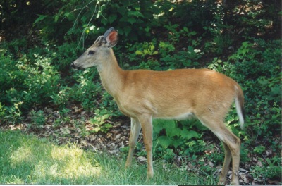
As we drove along Skyline Drive we enjoyed the scenery
and the wildlife. But we also enjoyed Tim, who entertained us with various
Runrig songs that he had learned by heart. For some peculiar reason both of our
children sing quite well, while both Dorte and I sings just as well as a hoarse
crow.
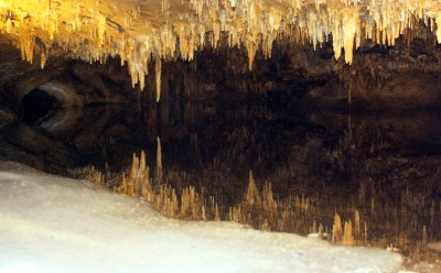 When we saw a sign
for Luray Caverns we decided
to visit the place. The caverns are the largest in the Shenandoah Valley with 5
miles of paths, of which the tour covers 1.5 mile. The caves includes virtually
all known variants of stalactites and stalagmites in many shapes and with many
different colors. The caverns also houses large
and small lakes, including a small lake where stalactites from the ceiling are
mirrored, so you think that there is also growing stalagmites from the bottom of
the lake.
When we saw a sign
for Luray Caverns we decided
to visit the place. The caverns are the largest in the Shenandoah Valley with 5
miles of paths, of which the tour covers 1.5 mile. The caves includes virtually
all known variants of stalactites and stalagmites in many shapes and with many
different colors. The caverns also houses large
and small lakes, including a small lake where stalactites from the ceiling are
mirrored, so you think that there is also growing stalagmites from the bottom of
the lake.
In one of the caves, known as the Cathedral, you find "The Great Stalagpipe Organ". It is an organ without pipes. Instead tones are created by small hammers striking specially selected stalactites, hereby making different tones. During tours the organ is played automatically, while on other occasions is played manually via a keyboard like any other organ. When we were there we had to make do with an automated version of "Oh Shenandoah". The temperature in the cave is 53° degrees year round and the day we visited it was around 80° outside, so it actually felt quite cold inside the caves.
When
the visit was over, we drove back to Skyline Drive and continued north. When
Dorte was in the area two years earlier, she had noticed a sign at a rest area,
that told the story of Tom Dooley, and close by was an trading post,that she wanted
to visit again. So we kept a close look on all rest areas, but we found no sign
- and no trading post. It turned out later that Dorte had remembered wrong. It
was not on Skyline Drive, she and Carl had seen the sign and shop, but on the
Blue Ridge Parkway and not in Virginia, but in North Carolina, so we didn't find
it at that occasion.
From Front Royal we went straight
to our hotel in Georgetown. In the afternoon Dorte and I went for a
walk while the kids enjoyed themselves in the room. When we came back we wanted
dinner, but none of us felt like going out again, so we simply ordered four
burgers from room service. And that completede that
day.