Volcanoes, houses and trees, but no wine
After completing our first
visit to Seattle, we were heading down south to Oregon. We had decided to take US-99 out of town, and then I-5
south. So we did. Before we left the US-99 however we we visited a supermarket where we bought a cool box. We only
paid $ 15 for the box so we felt that we could afford to "dump" it before we were
flying home. We
also bought ice, water and some bread and cold cuts, so we didn't have to buy
lunch the first few days. On the way from U.S. 99 to I-5,
we had an excellent view of Mount Rainier, and we decided that we would visit
the volcano when we got back to Seattle towards the end of the trip. Besides
from this short break we continued south, until we were about 50 miles from the
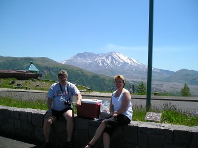
Oregon border. Here we left the interstate to go see Mount St. Helens, or what
was left of it after the eruption in 1980.
 Along
the way to the volcano, we made severeal stops at different viewpoints. The first stop we made at a visitor center about
7 or 8 miles from the interstate. From
here we could see the top of the volcano far away, and here we got a
folder that told about the 1980 eruption. We continued on towards the goal
and on the way we met a lot of people of all ages on bikes, but going in the opposite
direction. They rode alone or in larger and smaller groups, dressed in more or less
professional equipment. Even quite elderly people and very young children were biking
along, although some had to walk up the steepest hills. It turned out later that they
were participants in a race that stretched over about 100 miles (from the closest
town to the volcano and back, with a climb - and descent of around 5.000 feet). About
25 miles from out first stop we visited another view point. Here a
ranger pointed out some small brown blobs down in the valley, that he insisted was elks. Unfortunately, they were so far away that they
could have been anything, even dung heeps. The ranger also told, that
at the eruption in 1980 a layer of snow 150 feet thick around the top of the volcano
melted in three seconds. This had caused a 300 feet high tidal wave
flushing through the valley at a speed of 175 miles per hour, and when it had
passed, enter the lava flow, which at this point, several miles from the volcano,
were still moving at a speed of 60 miles per hour.
Along
the way to the volcano, we made severeal stops at different viewpoints. The first stop we made at a visitor center about
7 or 8 miles from the interstate. From
here we could see the top of the volcano far away, and here we got a
folder that told about the 1980 eruption. We continued on towards the goal
and on the way we met a lot of people of all ages on bikes, but going in the opposite
direction. They rode alone or in larger and smaller groups, dressed in more or less
professional equipment. Even quite elderly people and very young children were biking
along, although some had to walk up the steepest hills. It turned out later that they
were participants in a race that stretched over about 100 miles (from the closest
town to the volcano and back, with a climb - and descent of around 5.000 feet). About
25 miles from out first stop we visited another view point. Here a
ranger pointed out some small brown blobs down in the valley, that he insisted was elks. Unfortunately, they were so far away that they
could have been anything, even dung heeps. The ranger also told, that
at the eruption in 1980 a layer of snow 150 feet thick around the top of the volcano
melted in three seconds. This had caused a 300 feet high tidal wave
flushing through the valley at a speed of 175 miles per hour, and when it had
passed, enter the lava flow, which at this point, several miles from the volcano,
were still moving at a speed of 60 miles per hour.
We continued to the last view point (or rather the last we wanted to
visit, because there was another even closer to the volcano), and here we had a fantastic view of the volcano and the valley below
it. We took lots of pictures, hoping that some of
them would be good, and actually some did. Once more we listened to a ranger talk
before we went on - after enjoying our picnic with views to Mount St. Helens.
We then drove back to the highway, with only one more stop to enjoy the sight of a
bridge crossing over a deep gorge.
Back on the interstate, we continued south to Oregon, which we entered near the town of
Portland. The State boundary is on the outskirts of town, and here is NOT a
welcome center, and as ca matter of fact we visited none of these on this trip.
We continued through the city and further south, to the small town of Eugene,
where we had planned to stay overnight. But for the first time ever, we could
not get a room. We had previously (in 2004) expirienced a to try a hotel with no
vacancies,
namely, in Charlottesville, Virginia. On that occasion we just found one another hotel, but
that did not happen here. Every room in town were occupied and even if the
concierge phoned around to several other hotels, he got the same depressing message.
Even at the Hilton, we couldn't get a room. It turned out that there was a
BMX Racing event in town, so all the rooms, not just in Eugene but also
in the nearest towns were sold out. The consierge then suggested that we should
drive to Cottage Grove, which was approx. 20 miles further south. He thought
that town would be
outside the radius where the BMX participants ands spectators would stay. We
followed his advice, and he was right. We did find a hotel,
but unfortunately they had only one room vacant. It was a smoking room, but we were
allowed to go to the room and takr a sniff. We found that it wasn't too bad, so we
decided to stay the night, as we didn't want to continue further.
We see a lighhouse, big trees and a strange house
The next day we were going to see the Pacific Ocean for the first time. Or rather
I was as Dorte had already seen it, albeit from the other side when she was in
Japan.
Before we left Cottage Grove, we took a short drive though the town's
historic district, but there was not much to see, so we returned to the
interstate, which we followed a few miles to the south. Here we changed to Oregon Route 138, which
we followed west to the Pacific Ocean. It turned out to be a small, winding road
that led up through the Coast Range mountains, through small stands, and with a long section along the Umpqua
River. We had by now been driving for a few hours and needed to stretch our legs, so we chose a small picnic
area by the river. It turned out to be
close to a number of sand banks in the river, and there was a sign-post that told that this was
the Brandy Bar. The reason for this somewhat odd name was that when
the first ship with white men, sailed up the river in 1850, the ship ran aground
here and the sailors enjoyed themselves by emptying the ship's cargo of
brandy. And obviously not in the river!
 After our short
break, we continued towards the Pacific, and eventually we
came out of the mountains and onto a plain. Here we saw a lot of elks in the tall grass beside the road, and shortly afterwards
we got to an elk-viewpoint. There was also a ranger (they are
everywhere these days :-)), who told us about the animals - which, incidentally, could not
be seen
from the view point. The only animals we saw, were some pretty aggressive
swallows that nested under the roof of the small shed. When we
had listened to the ranger for a while, some people walking by and told us, that
they had seen some elks a bit further down the road, so we decided to take a
look at them. Unfortunately, they had disappeared when we got there. Instead of
looking at elks, we continued down the
road until it met with U.S. 101 near the town of Reedsport. Here we turned south,
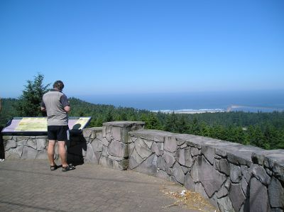
and shortly after we made a stop at a rest area where we had out first view of the Pacific.
Actually, we also had an excellent overview of the Umpqua River estuary. After having seen and photographed the Pacific, we continued south
along the main road.
After our short
break, we continued towards the Pacific, and eventually we
came out of the mountains and onto a plain. Here we saw a lot of elks in the tall grass beside the road, and shortly afterwards
we got to an elk-viewpoint. There was also a ranger (they are
everywhere these days :-)), who told us about the animals - which, incidentally, could not
be seen
from the view point. The only animals we saw, were some pretty aggressive
swallows that nested under the roof of the small shed. When we
had listened to the ranger for a while, some people walking by and told us, that
they had seen some elks a bit further down the road, so we decided to take a
look at them. Unfortunately, they had disappeared when we got there. Instead of
looking at elks, we continued down the
road until it met with U.S. 101 near the town of Reedsport. Here we turned south,
and shortly after we made a stop at a rest area where we had out first view of the Pacific.
Actually, we also had an excellent overview of the Umpqua River estuary. After having seen and photographed the Pacific, we continued south
along the main road.
The road led through forests that seemed to be very dry and there were a lot of
signs, warning about the danger of fire, while other signs warned that we were in
the tsunami area and that the road was a tsunami escape route. We met, however,
neither fires nor
tsunamis. The road passed along the area known as the Oregon Dunes, which for
some peculiar reason is an area of some very large sand dunes. There were several
opportunities to enter the dune area, but every time we saw a driveway, we
also saw a lot of small dune buggies, which were racing away through the dunes, so
we didn't find it was a convenient place to take a walk.
Our original plan had been to reach the Pacific Ocean somewhat further south, but
Dorte had seen on the map seen that U.S. 101 passed a small town called Denmark, and
that she wouldn't miss - but she did anyway!
At this time, she was acting as the driver, and when we reached the town, she
was only paying attention to her driving, and before I could say anything to her,
we had left the town again! This non-visit meant, that
we didn't pass two winieries, that I have planned to visit, but something have
to give :-), but no wine for me - at least at that occation. Since we thus had to
skip Denmark, we continued south to the small town of Bandon where we found a
shop where we could replenish with ice for the box. Here we also bought a
bottle of raspberry wine, but when we tried it the same evening, it tasted of neither wine nor raspberries, so this was our first and only try drinking
Oregon fruit wine. Bandon is by the way the center for the local production of
cranberries. More than 1,000 acres around the town are
planted with these berries, and here are harvested more than 5% of U.S. total production of berries. Ok, I admit that this is not the most necessary general
knowledge to possess, but now you do. In Bandon we also bought gasoline,
and here we saw one of the strange laws that exist in some U.S. states come to
life. In this
case it was prohibited in Oregon to fill petrol yourself.
 We continued south until we met a sign that pointed to the Cape Blanco lighthouse.
This we agreed to visit and also we would look for a place to have lunch with
more food from the ice box. When we got to the lighthouse the view was
breathtaking. A wild, rocky coast, and a pretty lighthouse.
Unfortunately, it stormed out there so we were almost blown away, and Dorte
thought it felt very cold as well, even though less than two miles further inland,
it was
too hot, so we decided to find another place to eat. When we had seen enough
of coast and lighthouse, we returned to the main road and
continued south for a few miles. Here we found a rest area overlooking the
Pacific Ocean and the beach. Here there were tables, and it was warmer, so
here we ate lunch, while we enjoyed the view. After lunch we continued south
along Highway 101, which from the town of Port Orford follows the coastline quite
close, so it's a very pretty ride. We crossed the border into California, and
stopped shortly after in a small town where there was a cafe. Here we got a cup
of coffee, before we continued south through Redwood
National Park. Here we for the first time saw the big, to say the
least, coast redwoods, which grows along the northern part of America's Pacific coast. We stopped so we
could take a few pictures of trees, cars and us. And even though Dorte was
somewhat dissatisfied with the trees - she found that the bark was "sloppy",
she did not mind being photographed with a sloppy tree.
We continued south until we met a sign that pointed to the Cape Blanco lighthouse.
This we agreed to visit and also we would look for a place to have lunch with
more food from the ice box. When we got to the lighthouse the view was
breathtaking. A wild, rocky coast, and a pretty lighthouse.
Unfortunately, it stormed out there so we were almost blown away, and Dorte
thought it felt very cold as well, even though less than two miles further inland,
it was
too hot, so we decided to find another place to eat. When we had seen enough
of coast and lighthouse, we returned to the main road and
continued south for a few miles. Here we found a rest area overlooking the
Pacific Ocean and the beach. Here there were tables, and it was warmer, so
here we ate lunch, while we enjoyed the view. After lunch we continued south
along Highway 101, which from the town of Port Orford follows the coastline quite
close, so it's a very pretty ride. We crossed the border into California, and
stopped shortly after in a small town where there was a cafe. Here we got a cup
of coffee, before we continued south through Redwood
National Park. Here we for the first time saw the big, to say the
least, coast redwoods, which grows along the northern part of America's Pacific coast. We stopped so we
could take a few pictures of trees, cars and us. And even though Dorte was
somewhat dissatisfied with the trees - she found that the bark was "sloppy",
she did not mind being photographed with a sloppy tree.
Shortly after we arrived at today's end goal, the Californian town of Eureka, where we found a hotel
with a vacant room at out first try. After checking in and moving our luggage to
the room we went to a mall at the outskirts of town and walked around here for a
while. Fortunately they
closed shortly after, so Dorte didn't have too much time to shop. But we spotted
a restaurant where we decided to dine later. Then we returned to the center of town, parked the car and went for a walk. First
to the
marina, which looked quite nice, and there was also a small fishing port. The town is most famous for its many Victorian houses
which are found throughout the Old Town. We walked around and took a look at a
few of them,
and several of them are actually more interesting than actually pretty, but
that's of course a
matter of preferences. Among the most interesting is the Carter House Inn, a Bed
& Breakfast in yellow colors, and Milton Carson Home, bright pink and
therefore nicknamed the
"Pink Lady". But strangest of all is
probably Carson Mansion. This house, which, incidentally, is kept in shades of
green, was originally built by lumber tycoon William M. Carson. Carson must have
had a particular penchant for gables and spires, for I have never seen so many of them
gathered in a single house. The building now houses a private club, and is unfortunately
not open to the public, so we had to settle for looking at it from outside.
Dorte drives through a tree
 Next morning we
were going further south to Napa. But first we
had to have breakfast, and as breakfast at the hotel was less appealing, we found
a diner instead. It was called Kristina's and it was in a pink house with a bright red sign,
and a lot of the interior was also pink. But the breakfast was excellent. I ordered
scrambled eggs with ham, potatoes and toast. When the food arrived,
it turned out that I basically got served a whole pig, I have never before been
served such a
large piece of ham for breakfast. But the taste was wonderful. Dorte ordered flap
jacks and neither of us could finish our meal. The coffee was as most American
coffee, not to good, but not bad either.
Next morning we
were going further south to Napa. But first we
had to have breakfast, and as breakfast at the hotel was less appealing, we found
a diner instead. It was called Kristina's and it was in a pink house with a bright red sign,
and a lot of the interior was also pink. But the breakfast was excellent. I ordered
scrambled eggs with ham, potatoes and toast. When the food arrived,
it turned out that I basically got served a whole pig, I have never before been
served such a
large piece of ham for breakfast. But the taste was wonderful. Dorte ordered flap
jacks and neither of us could finish our meal. The coffee was as most American
coffee, not to good, but not bad either.
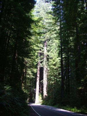
After breakfast we got under way going south, still at along U.S. 101. In the small town of Pepperwood
we left the highway for a while and changed to California State Route 254, alså
known as "Avenue of the Giants". This road leads
through Humboldt Redwood State Park for a distance of approx. 30 miles and if we
saw large trees the day before, we saw really, really large trees today! Humboldt Redwood
State Park is home to some of the world's tallest trees. In fact, five or six of the
ten tallest trees in the world grows in these woods, most in the part called Rockefeller
Forrest. This part of the forest contains 7 times as much biomass as a tropical
rainforest of the same size, which is a great deal. The big trees are, like
those we saw yesterday, coast redwood and the tallest of them all is actually in
Redwood National Park that we passed the day before. The tree is in a remote
part of the park and it's actual location is kept secret to keep tourist away.
This tree, called Hyperion is more than 379 feet tall. The tallest tree in
Humboldt State Park is the Stratosphere Giant at "only"
371 feet. These trees are evergreen conifers with very stringy bark which Dorte
as mentioned before felt
was sloppy. The trees can become very old. Many are up to 2,000 years
and the oldest known still living tree is 2,200 years old. However, there have
been found remains of trees that have been up to 3,000 years old. Tourist
brochures, typically from private forests, which speaks of trees up to 5,000 years, is
probably exaggerating quite a lot. The "Immortal
Tree" who stood outside a large souvenir shop we visited, is a
testament to how resilient these trees are. The tree which is approx. 1,000
years old, was originally 299 feet tall, but now it is only 243 feet after a
lightning cut of its top. In 1908 it suffered a wildfire and in 1964 it was
flooded and at one time, man tried to log it with axes, but the tree still stands, and
it is alive and well, hence the name.
We made several stops along Avenue of the Giants to look at and photograph the great redwood
trees, and in the small town of Myer's Flat we left the road to visit one of the
so-called "drive thru" trees - that is, a tree, you can drive through
in your car.
We wanted to try, even if it cost $ 3 at the time to get permission. As I had to
take the picture, it
was just Dorte who actually drove through the tree, while I remained outside the
car. After driving through we saw a little of some other trees, like one that was overthrown and cut so the growth rings was visible. Here were places
signs where you could see when Jesus was born, when the Magna Carta was signed, etc.
When we had driven all the way of Avenue of the Giants, we returned to Route 101
and continued south. At the town of Geyserville, we left the highway once more and
changed to California
Road 128. This road went through mountains and valleys. The mountains and valleys
are located in Sonoma County,
California's oldest wine region. One of the valleys we passed was Alexander Valley, where
the
vineyards and wineries are close. Alexander Valley is one of America's famous AVA's
(appellations). When we had passed 10 wineries over a distance of 3 miles, we thought it was
finally
time to visit a winery, now that I had missed the two in Oregon. So when we
passed one that was open, we went in. It turned out to be Alexander Valley Vineyards, which
is the oldest winery in the
valley - where the whole thing was started by Cyrus Alexander, who had given his
name to both the vineyard and the valley. The vwinery produces some excellent wines We tasted
some and bought a red and a
white, but unfortunately none of them survived the trip.
After the wine tasting we continued to Callistoga. The town is the northernmost in
Napa Valley, and offers both a petrified forest and a geyser, but neither
interested us enough to spend time visiting them. It was also late afternoon and we had been traveling for many hours. Instead we took the
California Route 29, which leads south through Napa Valley. This is California's
# 1 winegrowning region. Alone along CR 29, there are 37 wineries. In the town of St.
Helena is located among others Sutter Home, which is well known in Denmark.
Unfortunately, at 5.30 PM, when we got there, most of the tasting rooms had
closed for the day. We therefore decided to postpone further wine tastings for the next
day.
We found a hotel just outside Napa and when we were accommodated, we chose to eat at a
restaurant right next to the hotel. It was a Mexican restaurant where we had nachos for starters (for the first but
definitely not the last time on the trip) and fajitas for main course.
- Return to Surpise Trip -