How I got interested in the Tom Dooley case?
 From
Cherokee we took the Blue Ridge Parkway north, but
since we had already seen the southernmost stretch,
we chose to drive through Maggie Valley to
Asheville, and take the Parkway from there.
The road meanders across the mountains the first
several miles, and we were told, that the view was
magnificent.
Unfortunately it was raining and when the rain
stopped, it became foggy in stead so we never got
any views.
From
Cherokee we took the Blue Ridge Parkway north, but
since we had already seen the southernmost stretch,
we chose to drive through Maggie Valley to
Asheville, and take the Parkway from there.
The road meanders across the mountains the first
several miles, and we were told, that the view was
magnificent.
Unfortunately it was raining and when the rain
stopped, it became foggy in stead so we never got
any views.
At Craggy Gardens the hillside was covered with
rhododendron, and we had to stop to take some
pictures.
We also made stops at many overlooks, for instance
at Mt.
Mitchell, the highest mountain in eastern North
America.
Later we left the parkway at "Little Switzerland"
and again at some miles later to
visit Linville Cavern. We had fixed our minds on
visiting caves, and as we didn't succeed in
Kentucky, we wanted
to see some now.
The caves are at the foot of Humpback Mountain, and
we easily found the spot and bought a ticket.
As they didn't let too many people into the cavern
at one time, we had to wait about an hour before it
became our
turn.
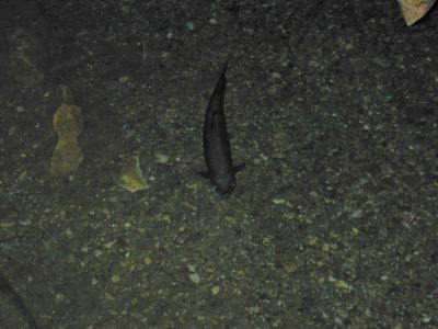
The caves were discovered in 1822 by the observation
of trout swimming in and out of the mountain.
Along the way through the caves we saw some of the
blind trout that live in total darkness and the
guide demonstrated what total darkness is, by
turning off the lights when we were quite far inside
the cave.
When the light was turned on again and we continued
our tour, we
saw one single sleepy bat.
In winter, many bats hibernate in the caves.
It also the home of Grand-daddy-long-legs (a kind of spider). The river also
serves as home to some kind of crayfish of which we saw none though.
After visiting the caves we headed back to Blue
Ridge Parkway and continued north, and passed
Grandfather Mountain by Lin Cove Viaduct. As it was
getting late, we
left the parkway
and headed towards the town of Boone,
county seat of Watauga County, where we got a room
in a nice hotel.
After a good night's sleep, we went back to Blue
Ridge Parkway and continued north.
We hadn't had enough of this beautiful road yet,
and there still were several things we wanted to
see.
The first place
was just somewhere Daniel Bone had passed in 1770 on his way west.
Immediately after the road was closed and we were
sent out on a 20 miles long detour.
When we got back to the parkway, we discovered that
the detour had only brought us
3-4 miles further north.
At The Lump we finally found the Tom Dooley sign, that we had been looking for two
years before.
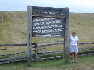 The
sign gave a very brief account of Tom Dooley being
hanged for murder. Up until then,
I didn't know anything about Tom Dooley. Not even
that the song referred to real event.
In our diary from this trip, I wrote a story about
the events.
This story was unfortunately completely wrong and
very misleading on many points, because I based it
on different websites' versions of the story.
Many of these have their knowledge from one another
and from the legends and songs about Tom Dooley, but
none of them has apparently chosen to investigate
the story themselves. If they did, they would have
known
that Tom was not the lover of two sisters, and murdered
one. Also they would have known that the victim did
not have a worshiper named Bob Grayson. That Grayson
was neither sheriff nor schoolteacher in the area.
That Tom was not arrested by sheriff Ferguson
and so on and so on.
Since then I started investigate further into the
matter and as a matter of fact I have written a lot
about the case
on my homepage. I might translate these pages too, some day.
The
sign gave a very brief account of Tom Dooley being
hanged for murder. Up until then,
I didn't know anything about Tom Dooley. Not even
that the song referred to real event.
In our diary from this trip, I wrote a story about
the events.
This story was unfortunately completely wrong and
very misleading on many points, because I based it
on different websites' versions of the story.
Many of these have their knowledge from one another
and from the legends and songs about Tom Dooley, but
none of them has apparently chosen to investigate
the story themselves. If they did, they would have
known
that Tom was not the lover of two sisters, and murdered
one. Also they would have known that the victim did
not have a worshiper named Bob Grayson. That Grayson
was neither sheriff nor schoolteacher in the area.
That Tom was not arrested by sheriff Ferguson
and so on and so on.
Since then I started investigate further into the
matter and as a matter of fact I have written a lot
about the case
on my homepage. I might translate these pages too, some day.
When we had looked at the sign and all in turn had
been photographed next to it, we continued our
journey north to our next stop at the Northwest
Trading Post, a general store and outlet for many of
the artisans who lives in Blue
Ridge Mountains. After visiting the store and buying
a few necessary items, we took some pictures
of the variants of wooden split-rail fences that are
richly represented in the eastern South.
The last stop we made before we left the parkway,
was at the Brinegar Cabin.
It is a small house made of wood with only two rooms
that had been inhabited by the Brinegar family right
up until 1933.
While we were at the cottage, we noticed an eagle
above, and that resulted in one of my father-in-law, Carls immortal gems: "Look, what a
nice eagle."
Since that day, the term "Look, what a nice
eagle" has become a part of the family's standard
vocabulary, although the eagle is sometimes replaced
with other animals, such as "Look, what a nice seagull"
- in Denmark eagles are not exactly growing on
trees, if I you know what I mean.
We left the parkway shortly after that and headed for the highway, and our
last Welcome Center on this trip.
From the state border we took the Interstate north
to Lexington, where we had also stayed two years
earlier.
After getting a room at a hotel, I no longer remember which, we
went into town.
Last time it was only Dorte and I, who went, but
this time Carl went along, while Else stayed at the
hotel. We saw almost all the same sights as
two years earlier, including the Stonewall Jackson
Memorial Cemetery.
After our visit here, we concluded this part of our
trip. Now we only had one leg left, back to DC.
By the way, our search for the Tom Dooley sign, and another of Carls sayings, are mentioned in the article Bridges, bullits, bats and a cavern on the 2000 page.